ROUTE 12: MUTLA RIDGE
Mutla Ridge
Mutla Ridge
The Mutla
Ridge is located in Al Jahra Governorate. It is the highest point in Kuwait, at
306 metres high.
During the
Gulf War, the Iraq forces were going to launch bombs while they were on the
ridge to threaten Saudi Arabia. In February 1991, American aircraft attacked
retreating Iraqi forces fleeing Kuwait in the direction of Basra on the
"Highway of Death."
Coalition
forces later used the rocky outcropping for communication towers, to
communicate with troops in Iraq.
During
operation "Desert Spring" in 2003, a detachment of the Oklahoma
National Guard 45th division 1/179 infantry B company followed by the Indiana
National Guard watched and defended the outpost until late in the war, when
they were moved to Tallil Air Base in Iraq. Also watching over the Ridge in
2003, was the 946th Transportation Co., a reserve unit, out of Lewes, DE.
(Sources: Wikipedia)
Direction:
Get on the
sixth ring road and drive until you pass jahra and the 80 intersection (it's
around the 51KM distance marker). Drive straight towards subiya, once you pass
the weather balloon, take the first bridge to the right (Bridge 630), once you
come down the slope, park anywhere on the left.
Coordinate:
29.406555 N, 47.701434 E
Time & Date
11 Nov 2016, 7:30
am
Location:
Seaside of Bridge 630 (the first
bridge) Subiya road.
Terrains
50% Hard compounded sand
40% Loose compounded sand
10% Tarmac
CYCLING TIME
Total Distance: 25.2 km
Riders:
1. Bobak (Led)
2. Ahmad
3. Khalid
4. Mike
5. Ion
6. Robin
7. Aswade
8. Shelly
9. Lavinia
Total Distance: 25.2 km
Riders:
1. Bobak (Led)
2. Ahmad
3. Khalid
4. Mike
5. Ion
6. Robin
7. Aswade
8. Shelly
9. Lavinia
Strava Record
Note: Unrecorded for 7.2km
Google Map:
As usual, briefing for leader after taking attendance. For this ride Bobak led us for another adventures ride in Kuwait.
KM 1- KM 4 (4km)
Mixed compounded sand terrains. Some parts, we need to push our bike. Toward the end, very compacted sand, we can cycle very fast.
KM 4 - KM 10 (6km)
100% Tarmac; near to the beach.
I saw a house near to the beach. Quite remote from others. Selfie with camel shepherd.
KM 10 - KM 15 (5km)
Offroad - Mixed compounded sand
We stopped for awhile, take 5.
Selfie
We cycled until reaching to a roundabout about 5km from RV point towards to Boubyan Island road.
Bobak as tourist guide...
Khalid
Boubyan Island, other place to be rode.
We went to camping area.
KM 15 - KM 21 (6 km)
This is our climate challenges. Very touch; we couldn't ride at thick soft sand. I tried to reduce air pressure on the tires.
I looked like a mini Grand Canyon in Kuwait
Group photos
Push your bike

Ahmad
Bobak

Khaled

Ion
Uphill
We reached a flatted plateau


KM 21 - KM 25 (4 km)
100% Tarmac - Downhill !
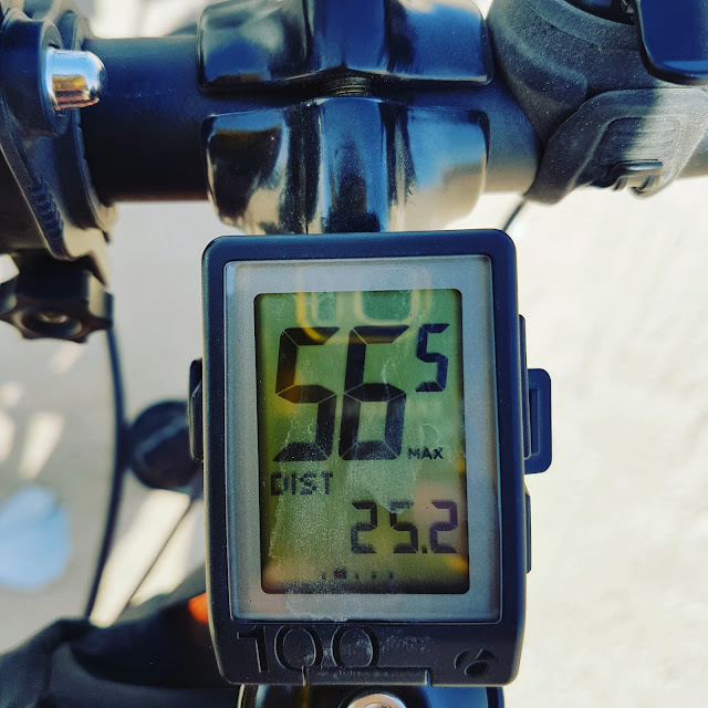
Started from Mutla Repeater Station. Downhill on a winding road at maximum speed 56km/hr. Scary.
We arrived RV at 10:30 am.
----------------------- END------------------------


No comments:
Post a Comment